Hydrographic Survey Management
Manage and plan your hydrographic survey programme
The Hydrographic Survey Management Extension for Maritime Toolbar will help you:
- streamline data and information exchange
- quickly monitor the status of survey areas
- enable a consistent approach to data management
- easily share and exchange information with others
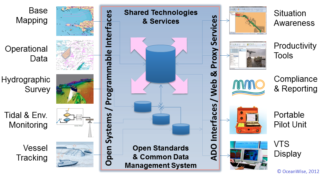
The Hydrographic Survey Management Workflow Extension is not a survey control or processing package; there are many established applications that do this work. By complementing these packages, the extension provides an overview of survey needs and helping to manage a survey programme. On completion, survey metadata is recorded to create a survey history that can be shared with stakeholders. It enables you to:
- register published charts and maintain a record of status and latest survey data
- generate survey boundaries and link them to predefined seabed/chart areas
- generate reports of programmes for performance monitoring and planning
- create and maintain metadata for each survey according to IHO standards
Managing your survey data better with this tool makes it easier for you to produce your own Port and Bathymetric ENCs. See Electronic Navigational Charts Production
Learn More
- Productivity Tools – Maritime Toolbar and Workflow Extensions
- Dredging and Licensing Management
- Environmental Samples Management
- Object Based Image Analysis
- Electronic Navigational Charts (ENC) Production
- Ocean Database
- Spatial Data Management & GIS
- ABP Port of Southampton benefits from GIS
- Hydrographic Survey Management Extension Brochure
- What Is Your Data Challenge?