LinkedIn Logo Twitter Logo Twitter Logo
Log into Port-Log.net
Contact Page
+44 (0) 1420 768262
    • Home
    • About
      • About Us
      • News & Views
      • Events
      • Newsletters
      • Partners
      • Find a Partner
      • Professional Bodies
      • Our People
      • Careers
      • Contact Us
    • Sectors
      • Overview
      • Ports and Harbours
      • Maritime Pilotage
      • Offshore Renewables
      • Governments and Agencies
      • Customer Case Studies
      • Data as Infrastructure
    • Compliance
      • Compliance Overview
      • Marine Data Management
      • Asset Management System (AMS)
      • Aids to Navigation Management System
      • Conservancy Management
      • Spatial Data Management & GIS
      • Environmental Monitoring
      • Our Courses
    • Monitoring
      • Overview
      • Consultancy and Advice
      • Design and Integration
      • Installation and Maintenance
      • Data Telemetry
      • Data Collection, Management and Display
      • Air Quality for Ports
    • Training
      • Our Courses
      • Data Management
      • Data Management for Ports
      • Introduction to Change Management
      • Capacity Building
      • Technical Training
      • Product Training
      • Our Workshops
    • Mapping
      • Overview
      • Marine Themes Vector
      • Marine Themes DEM
      • ENC Web Map Service
      • Raster Charts
      • Raster Charts XL
      • Raster Charts XL Oceans
      • Mapping Data Buying Guide
      • Mapping Data FAQs
      • Data Originators
      • Vector Feature Catalogue
    • Partners
      • Overview
      • Become a Partner
      • Find a Partner
    • Support
      • Downloads
      • Portal
      • Support
      • Glossary of Terms
      • Contact Us
      • Terms and Conditions
banner
When you need to streamline your processes and workflows and support situational analysis

When you need to streamline your processes and workflows and support situational analysis

Enterprise GIS and productivity tools

When you need to streamline your processes and workflows and support situational analysis

When you need to streamline your processes and workflows and support situational analysis

Enterprise GIS and productivity tools

    Poor data management can put your operations at risk. Read our top tips to achieving marine data management success now.

    By completing this form, you consent to receive marketing and our newsletter emails from OceanWise. To opt out, please email info@oceanwise.eu, or click "unsubscribe" on the email you receive from us. We will not share your contact details with any third party.

Software Overview

OceanWise > Software Overview
Enterprise GIS and Productivity Tools

Modernise your approach to data management with our software productivity tools and streamline your processes and workflows

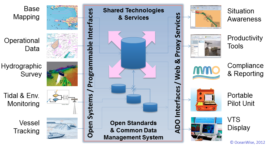
OceanWise can help you modernise your approach to data management. We provide tools and expertise that streamline workflows, support situational analysis and improve decision support.

By combining our own software tools with the power of Geographic Information Systems (GIS) to store, analyse and disseminate environmental, asset and other maritime data with a spatial component, we ensure that you always have the data you need when you need it.

Our tools support the planning and management of your hydrographic surveys, dredging and licensing, environmental sampling and associated reporting. The simplification of complex processes are simplified means tasks that previously took hours can be completed in just a few minutes.

Productivity tools
Maritime Toolbar is a suite of software tools that manipulates maritime data directly in GIS, making common operational processes associated with environmental data management and reporting much easier.


Dredging & Licensing Management
Save time by streamlining tasks related to the management and reporting of your dredging operations.


Hydrographic Survey Management
Manage the planning and recording of your hydrographic surveys more effectively, allowing survey history and metadata information to be stored, analysed and extracted to inform survey programmes and needs.


Environmental Samples Management
Store and manage the results of your environmental sampling and simplify the exchange of data between regulators, survey companies and other stakeholders.


Object Based Image Analysis Extension / RSOBIA
Interpret and digitalise areas and boundaries in a marine image quickly and easily.


Electronic Navigational Charts (ENC) Production
Create your own bathymetric, port and other types of electronic navigational charts.


Data Storage & Management
When you are looking for an easy way to store and manage complex marine environmental data in a diverse range of formats, our Ocean Database (ODB) is the complete data management solution.


Enterprise GIS
We can help you realise the benefits of using GIS to store, analyse and disseminate environmental, asset and other data with a spatial component.

What is your data challenge?

Take the test, and find out how you could save time and money by modernising your approach to data management

What is your data challenge?

Learn More

  • Productivity Tools – Maritime Toolbar and Workflow Extensions
  • Dredging and Licensing Management
  • Hydrographic Survey Management
  • Environmental Samples Management
  • Object Based Image Analysis
  • Electronic Navigational Charts (ENC) Production
  • Ocean Database
  • Spatial Data Management & GIS
  • ABP Port of Southampton benefits from GIS
  • Bathymetric and Port ENCs for Peel Ports Pilots
  • What Is Your Data Challenge?
The specialist maritime tools and expertise provided by OceanWise are now integral to our operations.

ABP Southampton

Peel Ports

Knowing our in-house Survey Team can now do a survey and create ENCs quickly gives us increased confidence and security with any pilotage operation, and will assist us in planning and executing future large ship movements.

Gillan Locke - Marine Officer

Why OceanWise?

We are proud to be: Independent. Experienced. Innovative. International. Trusted.

ISO 9001ISO 14001ISO 45001cyberessentials certification

© OceanWise 2023. OceanWise Limited is an independent company specialising in marine environmental data acquisition, management, publishing and GIS.
Registrar of Companies of England and Wales No. 7206926 and Companies Registration Office Ireland No. 641571.

Terms & Conditions | Privacy Notice | Contact Us

OceanWise HelpBot

Still need help?